


– Import collected data in DJI Terra to process the scene 3D model.
– Use DJI Modify to clean a version of the 3D model, remove any floating parts, and improve overall texture quality. Sharing with other stakeholders is also possible.

- Industries
- Products
Remote Drone Operation Solutions

Developer Technologies

Accessories
- Insights
- Events
- Eco System
- Data Security
- Support
- Industries
- Products
Remote Drone Operation Solutions
Developer Technologies
Accessories
- Insights
- Events
- Eco System
- Data Security
- Support
Collision Reconstruction and Forensics
Clear roads faster with efficient and accurate drone-based data collection and reconstruction. Ensure personnel safety and digitize your forensics process.
Painpoints
- There is an increased risk for forensic personnel when performing manual reconstruction.
- Traffic is significantly impacted by the long reconstruction times and delays in road clearing.
- Inadequate data collection and a lack of realistic visual representation can add complexity to legal cases.
Advantages
- Collect data from a safe distance without compromising data quality or exposing personnel to unnecessary risk.
- Significantly reduce collection times, restoring normal traffic flow more quickly and minimizing the impact on transportation.
- Capture realistic reconstruction models of the scene, which can be later used throughout the legal process.
Solution
Portable Scene Reconstruction
Large Scale Scene Reconstruction
Portable Scene Reconstruction
The Mavic 3E offers unparalleled portability for quick reconstruction missions. Easy to carry in patrol vehicles and equipped with a 20MP camera and RTK module, it’s an ideal solution for fast but accurate scene reconstruction. Paired with DJI Terra and DJI Modify, it can create realistic 3D models to serve as evidence or for forensic analysis.
- 20MP 4/3 CMOS Sensor for high-quality reconstruccion models.
- Compact and lightweight design, less than 1kg and easy to carry in a patrol vehicle.
- Fast and easy deployment, get airborne in around 30 seconds.
- Mechanical shutter with 0.7s interval to improve efficiency and reduce data collection times.
- Automated mapping mission modes to optimize data collection.
Payload And Software

DJI Pilot 2
Ground control

DJI Terra
Modeling and flight mission plan

DJI Modify
Intelligent 3D model editing software
Workflow
1) Mission Planning:
– Plan Mapping Mission based on scene reconstruction needed.
2) Mission Execution:
– Execute the planned mission. Complement the images with POI flights using timed photo capture.
– For night reconstructions, make sure to properly light the scene for accurate data collection.
3) Post Mission Documentation:
– Import collected data in DJI Terra to process the scene 3D model.
– Use DJI Modify to clean a version of the 3D model, remove any floating parts, and improve overall texture quality. Sharing with other stakeholders is also possible.
– Live stream the drone images to command centers through DJI FlightHub 2.
Large Scale Scene Reconstruction
The Matrice 350 RTK, equipped with the Zenmuse P1, allows law enforcement and forensic teams to map vast incident areas with great quality and accuracy. Process the collected data with DJI Terra and DJI Modify for optimal processing efficiency and modeling quality.
- Reliable multipurpose drone platform for reconstruction missions in challenging conditions.
- Zenmuse P1 has a 45MP, full-frame sensor to ensure high-quality data collection.
- Generate accurate centimeter-level deliverables.
- Field-work efficiency—covers 3 km² per flight, delivering a 5cm GSD.
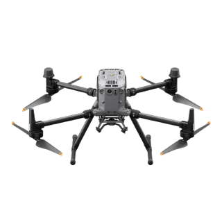
Drone Platform

Matrice 350 RTK
Weight: Approx. 6.47 kg(with single downward gimbal and two TB65 batteries).
Payload And Software

Zenmuse P1
45 MP Full-frame camera.
Global Mechanical Shutter Shutter Speed 1/2000 Seconds.
DJI Pilot 2
Ground control
DJI Modify
Intelligent 3D model editing software
Workflow
1) Mission Planning:
– Plan Mapping Mission based on scene reconstruction needed.
2) Mission Execution:
– Execute the planned mission. Complement the images with manual flights.
– For night reconstructions, make sure to properly light the scene for accurate data collection.
3) Post Mission Documentation:
Contact Us
For more information about product demo or trial, leave your contact information in the form below. You can also reach out to your local dealer for more information.
Mission Situational Awareness
Collision Reconstruction and Forensics
Urban Fires
What are you waiting for? Contact us right now and get a free quote for your project
About Us
At Rarlon Tech, we are proud to bring you cutting-edge solutions by offering a wide range of products from DJI Enterprise, a globally recognised leader in drone technology. Our partnership with DJI ensures you receive high-quality, reliable, and innovative tools to meet your business and operational needs.
Explore
Support
Copyright © 2024 Rarlon Tech. All Right Reserved.