
- Industries
- Products
Remote Drone Operation Solutions

Developer Technologies

Accessories
- Insights
- Events
- Eco System
- Data Security
- Support


- Industries
- Products
Remote Drone Operation Solutions
Developer Technologies
Accessories
- Insights
- Events
- Eco System
- Data Security
- Support
Precision Agriculture
optimizing crop management and effective disease control.
Painpoints
- It's difficult to accurately locate the crop areas that need attention without geotaged data.
- Manual samplings are lengthy and labor consuming, thus reducing the possible sampling frequency.
- Traditional crop evaluation methods rely on observation with limited data analysis.
- Limited visibility of the crop field overall health.
Advantages
- Evaluate health and prevent diseases of each invidual crop with georeference data collection.
- Increase data sampling frequency with fast aerial data collection.
- Access a variety of data including RGB images, multispectral, thermal, and LiDAR data.
- Cover larger areas in a single flight.
Solution
Portable Drone for Mapping and Stand Count Analysis Solution
- Portable solution, easy to operate and to carry across multiple farms and fields.
- Centimiter level data thanks to its mechanical shutter and RTK capability.

Workflow
- Data Collection: Plan a 2D map mission for regular orthomosaic data acquistion or waypoint mission for site video recording and pano stiching.
- Data Processing: Import to collected images into DJI Terra to create 2D maps and 3D Models.
- Data Analysis: Seamlessly integrate the results into third-party software for advanced stand count analysis, enhancing efficiency and accuracy in agricultural assessments.
Portable Multispectral Data Collection Solution
- Portable solution, easy to operate and to carry across multiple farms and fields.
- Centimiter level data thanks to its mechanical shutter and RTK capability.
- Vegetation health assessment with multispectral sensors.
- Prescription map generation with DJI Terra.
Drone Platform

DJI Mavic 3M
Net Weight (with propellers and RTK module):951g. Max Flight Time (without
Payload And Software

Zenmuse H20T

DJI FlightHub 2
Drone and dock's cloud management system
Workflow
- Data Collection: Plan a 2D mission and activate the multispectral sensor to acquire an aerial map enriched with multispectral bands data, providing a comprehensive view for precise analysis.
- Data Processing: Import to DJI Terra to process the captured images, and generate 2D models if needed.
- Data Analysis: Analyze the collected vegetation indexes for in-depth analysis of crop health. Generate prescription maps for accurate crop spraying.
Precise Visual Vegetation Analysis Solution
- Field-work efficiency, covers 3 km² per flight delivering a 5cm GSD.
- Reliable multi-purposed drone platform designed to endure harsh environments and conditions.
- Zenmuse P1 has a 45MP, full-frame sensor to ensure high quality data collection.
- Suitable for AI-Driven disease detection through high resolution imagery.
Drone Platform
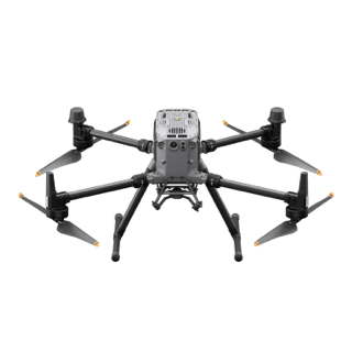
Matrice 350 RTK
Weight: Approx. 6.47 kg(with single downward gimbal and two TB65 batteries).
Payload And Software
Zenmuse H20T
45 MP Full-frame camera. Global Mechanical Shutter Shutter Speed 1/2000 Seconds

DJI Pilot 2
Ground control

DJI Terra
Modeling and flight mission plan
Workflow
- Data Collection: Plan a 2D mission and activate the multispectral sensor to acquire an aerial map enriched with multispectral bands data, providing a comprehensive view for precise analysis.
- Data Processing: Import to DJI Terra to process the captured images, and generate 2D models if needed.
- Data Analysis: Analyze the collected vegetation indexes for in-depth analysis of crop health. Generate prescription maps for accurate crop spraying.
Crop Biomass and Lanscape Analysis Solution
- Field-work efficiency—covers 3 km² per flight, collecting both LiDAR and RBG data.
- Highly integrated solution, reducing on-site time and ensuring data capture quality.
- Reliable multi-purposed drone platform designed to endure harsh environments and conditions.
Drone Platform
Matrice 350 RTK
Weight: Approx. 6.47 kg(with single downward gimbal and two TB65 batteries).
Payload And Software
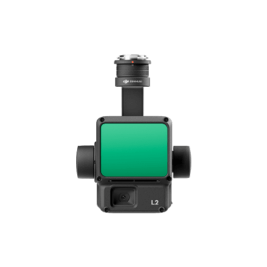
Zenmuse L2
Integrates frame LiDAR, a self-developed high-accuracy IMU system, and a 4/3 CMOS
DJI Pilot 2
Ground control
DJI Terra
Modeling and flight mission plan
Workflow
- Data Collection: Plan a 2D mission to collect both Point Cloud and true color images, providing comprehensive data for accurate analysis of crop characteristics.
- Data Processing: Import to DJI Terra to process for DOM, DSM, Point Cloud, orthomosaic images and 3D models.
- Data Analysis: Import the acquired models into your preferred 3rd party software for further crop classification, volume estimation, and biomass classification.
Large Farm Coverage & Routine Sampling Solution
- Schedule routine data collection flights over the construction site to efficently track project progress.
- Upload the collected data into DJI FlightHub 2 or preferred 3rd party software for in-depth crop analysis.
Drone Platform
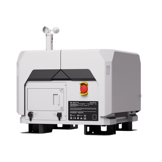
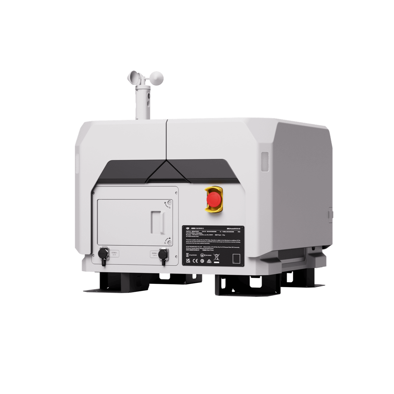
DJI Dock 2
Weight: 34 kg (without the drone). Size: length 570 mm, width 583 mm, height 465 mm.
Workflow
- Data Collection: Plan a routine 2D map mission for regular orthomosaic data acquisition.
- Data Processing: Import collected data into your preferred 3rd Party Software for in-depth crop analysis.
- Data Analysis: Use the captured images to train specialized AI models for efficient disease detection.
Contact Us
For more information about product demo or trial, leave your contact information in the form below. You can also reach out to your local dealer for more information.
What are you waiting for? Contact us right now and get a free quote for your project
About Us
At Rarlon Tech, we are proud to bring you cutting-edge solutions by offering a wide range of products from DJI Enterprise, a globally recognised leader in drone technology. Our partnership with DJI ensures you receive high-quality, reliable, and innovative tools to meet your business and operational needs.
Explore
Support
Copyright © 2024 Rarlon Tech. All Right Reserved.