


– Upload the videos and images collected to DJI FlightHub 2 or download from the aircraft SD card for evidence reports or mission debrief.

- Industries
- Products
Remote Drone Operation Solutions

Developer Technologies

Accessories
- Insights
- Events
- Eco System
- Data Security
- Support
- Industries
- Products
Remote Drone Operation Solutions
Developer Technologies
Accessories
- Insights
- Events
- Eco System
- Data Security
- Support
Mission Situational Awareness
Gain aerial intel on developing situations with real-time, high-quality imagery, supporting ground teams and enhancing decision-making.
Painpoints
- Traditional air support, such as helicopters, is limited and costly, leaving ground teams to cover vast areas.
- A lack of comprehensive mission information results in exposing ground teams to unnecessary risk.
- Information is scattered between multiple ground teams and the command center, hindering the response's effectiveness and mission success.
Advantages
- Deploy timely and cost-effective aerial support to assist patrol and tactical teams.
- Eliminate uncertainty with visual and thermal drone data, uncovering hidden dangers and de-escalating situations.
- Coordinate teams positions and improve tactical deployment through easy-to-share, live-streamed drone imagery.
Solution
Portable and Fast Aerial Response
The Mavic 3T solution offers unparalleled portability for quick reconnaissance missions. Easy to carry on patrol vehicles and equipped with high-resolution visual and thermal sensors, it’s an ideal solution for gaining intel on unexpected situations.
- Thermal and visual sensors to gather comprehensive aerial intel for your missions.
- Compact and lightweight design, less than 1kg and easy to carry in a patrol vehicle.
- Fast and easy deployment, get airborne in around 30 seconds.
- Superior flight performance with flight time of up to 45 min.
Payload And Software

DJI FlightHub 2
Drone and dock's cloud management system

DJI Terra
Ground control
Workflow
1) Mission Execution:
– Using DJI Pilot 2 App, add the target location to the map as a GPS Pin.
– Deploy the drone and manually fly towards the area of interest.
– In DJI Pilot 2 Camera View, use AR of the pin to guide the pilot toward the correct location.
– Activate discrete mode for night tactical or sensitive operations.
– Switch between infrared and visual views or use both at the same time to evaluate the situation and provide enhanced situational awareness to ground teams.
2) Post Mission Documentation:
– Upload the videos and images collected to DJI FlightHub 2 or download from the aircraft SD card for evidence reports or mission debrief.
Weather Resistant and Quick to Deploy
The Matrice 30T, equipped with its hybrid sensor and smart features, provides enhanced situational awareness. Rated with an IP55 Ingress Protection, the M30T is suited to perform under harsh conditions, offering unmatched reliability.
- Hybrid payload featuring visual, thermal, and laser range finder sensors provides enhanced mission insights.
- Robust and weatherproof airframe graded IP55, allows you to fly when is most needed.
- Smart Track and Pin Point features to ease flight operation while keeping targets of interest in frame.
- Hot-swappable batteries for continuous operation.
- Optical Zoom for mission reconnaissance and target identification from a safe distance.
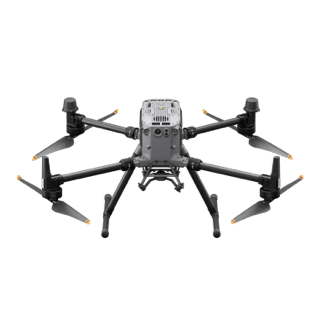
Drone Platform

Matrice 30T
Weight (incl. two batteries): 3770 ± 10 g.
Max Flight Time: 41 min.
Payload And Software

DJI FlightHub 2
Drone and dock's cloud management system
DJI Pilot 2
Ground control
Workflow
1) Mission Execution:
– Using DJI Pilot 2 App, add the target location to the map as a GPS Pin.
– Deploy the drone and manually fly towards the area of interest.
– In DJI Pilot 2 Camera View, use AR of the pin to guide the pilot toward the correct coordinates.
– Activate discrete mode for night or sensitive operations.
– Switch between infrared and visual views to evaluate the situation and provide enhanced situational awareness to ground teams.
– Use the Smart Track function to keep track of moving objects while reducing pilot cognitive load.
– Pin locations of interest and easily center the camera on them.
2) Post Mission Documentation:
– Upload the videos and images collected to DJI FlightHub 2 or download from the aircraft SD card for evidence reports or mission debrief.
Outdoor Overwatch Day or Night
The Matrice 350 RTK sets the standard for high-performance, multipurpose drone solutions. Equipped with the Zenmuse H30T multi-sensor payload, which includes zoom, wide, and thermal cameras, it provides optimal performance for law enforcement overwatch operations, day or night.
- Robust and weatherproof airframe graded IP55, allows you to fly when is most needed.
- Night Scene Mode and NIR Auxiliary Light features for night operations.
- Optimal operational efficiency with extended flight time of up to 55 min.
- Laser detection range up to 3,000 meters to get the accurate location of points of interest.
Drone Platform

Matrice 350 RTK
Weight: Approx. 6.47 kg(with single downward gimbal and two TB65 batteries).
Payload And Software

Zenmuse H30T
Weight: 920±5 g.
Ingress Protection Rating: IP54.
Zoom Camera: 1/1.8-inch CMOS, Effective Pixels: 40 MP.
DJI FlightHub 2
Drone and dock's cloud management system
DJI Pilot 2
Ground control
Workflow
1) Mission Execution:
– Using DJI Pilot 2 App, add the target location to the map as a GPS Pin.
– Deploy the drone and manually fly towards the area of interest.
– In DJI Pilot 2 Camera View, use AR of the pin to guide the pilot toward the correct coordinates.
– Activate discrete mode for night or sensitive operations.
– Switch between infrared and visual views to evaluate the situation and provide enhanced situational awareness to ground teams.
– Use the Smart Track function to keep track of moving objects while reducing pilot cognitive load.
– Pin locations of interest and easily center the camera on them.
2) Post Mission Documentation:
Contact Us
For more information about product demo or trial, leave your contact information in the form below. You can also reach out to your local dealer for more information.
Mission Situational Awareness
Collision Reconstruction and Forensics
Urban Fires
What are you waiting for? Contact us right now and get a free quote for your project
About Us
At Rarlon Tech, we are proud to bring you cutting-edge solutions by offering a wide range of products from DJI Enterprise, a globally recognised leader in drone technology. Our partnership with DJI ensures you receive high-quality, reliable, and innovative tools to meet your business and operational needs.
Explore
Support
Copyright © 2024 Rarlon Tech. All Right Reserved.